Moist Parcel-in-Cell method
This code has been developed by scientists in a collaboration between the University of St Andrews and the University of Leeds (ICAS). Instead of modelling variables on a grid, as is most common in atmospheric science, the variables are modelled by following parcels of fluid, which carry a volume, thermodynamic properties (heat and moisture), and part of the flow circulation around with them. Many quantities are approximately conserved following the motion of any given parcel, so that following the motion of parcels is an efficient way of calculating the flow evolution. The parcel approach is not generally used in atmospheric science, and one aim of this work is to demonstrate that it can be much more efficient than the widely used grid method, so that the atmosphere can be predicted in more detail with given computational resources.
 The code is currently constructed so that it uses as simple a set of equations as possible, to represent the development of a moist thermal. The atmosphere is modelled as a neutral boundary layer overlaid with a stably stratified atmosphere. An underlying grid is still used to construct the velocity fields (which derive from the circulation on the individual parcels), and these gridded fields are interpolated to parcel positions to advect the parcels.
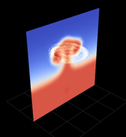
A 3-dimensional graphical user interface (GUI) displays the evolution of parcel positions, along with thermodynamic properties, as the calculations proceed. The figure shows an example snapshot from this GUI. The parcels are coloured according to their horizontal distance from the centre of the domain. In this example, the parcel positions are overlaid with a vertical cross-section of total water content.
 This figure shows specific humidity fraction in vertical cross-section, for a well-developed thermal. Although the model is highly idealised, it captures the complex process of cloud formation and development well. The velocity fields are defined on a grid with 384 grid points in each of the three directions. The humidity field has been interpolated from the parcel positions onto a grid that is 6 times finer in each direction. This high-resolution image is not part of the GUI, but has been produced during a simulation.
Please see the following links for further information:
http://www-vortex.mcs.st-and.ac.uk/~dgd/clouds.html
www1.maths.leeds.ac.uk/mathsforesees/feas_report_Dritschel.pdf
